Mitigating the risks posed by GNSS jamming and spoofing in VTS operations requires a combination of technical measures, operational procedures
Navigation outages once confined to battlefields now span shipping lanes, air corridors and telco networks. The pattern is visible from space — if you know where to look. ”The data show a pattern that can no longer be ignored. There are clearly serious concerns that this situation is not improving.
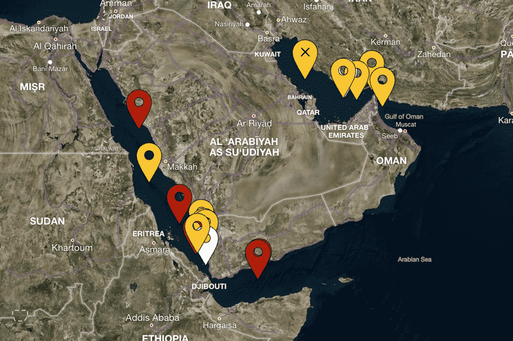
Meanwhile GNSS interference has expanded from two regional hotspots, the Black Sea and the Baltic, to at least six key maritime areas: the Mediterranean Sea, the Red Sea, the Persian Gulf, the Caribbean Sea, the Black Sea, and the Baltic Sea. Some interference has been experienced in the South China sea, but very little has been experienced in UK and USA coastal waters. Where In 2025, at least two collisions and groundings were reported in mainstream media linked to Global Navigation Satellite Systems (GNSS) interference in regions such as the Baltics, Straits of Hormuz and the Red Sea.
RIN recently released its maritime report.
The UK’s Royal Institute of Navigation (RIN) issued recently its maritime report revealing the impacts of GNSS interference in the maritime sector. Meanwhile the RIN Maritime GNSS Interference Working Group has assessed that the impact of GNSS interference on maritime safety, vessel operations, and port security is very serious, with 75% of the respondents are of the opinion that this situation is not improving. Of the 271 respondents, 212 reported that they had experienced GNSS interference (79% of those surveyed).
GNSS or AIS interference
On the other hand Around 2% of the respondents reported that the UK and USA regions had experienced GNSS or AIS interference, but this proportion is lower than the margin of error (±6%) for the size of this dataset, and so no firm conclusion can be drawn here (i.e. those responses were so rare relative to the sample size that they could have been caused by accidental/erroneous survey selections).By comparison in the Persian Gulf, over 80% of those who had been in that region had experienced GNSS or AIS interferenc

The systems that be impacted the most often include the GNSS
The systems reported to be impacted the most often include the GNSS receiver (85% of respondents), AIS (75% of respondents), ECDIS (70% of respondents) and RADAR (51% of respondents).Systems that historically have not required any access to GNSS data in order to function, such as the VHF,MF/HF and NAVTEX radio systems are also reported in the survey as being disrupted during GNSS interference, with 29% of respondents reporting issues with their VHF,MF/HF radios, and 15% reporting issues with NAVTEX. While Issues with satellite communications were reported during GNSS interference by 33% of respondents Similarly, 35% of the respondents reported Global Maritime Distress and Safety Systems (GMDSS) being impacted during GNSS disruption, with 11% of respondents specifically reporting time being displayed incorrectly on their GMDSS.
According to SOLAS (Safety of Life at Sea)
Of most concern are the SOLAS (Safety of Life at Sea) required equipment and systems, with 7% of respondents reporting that they had seen the time displaying incorrectly on SOLAS required systems during GNSS disruption.The other systems that the survey respondents indicated were known to be impacted during GNSS interference were: gyrocompass, autopilot, Doppler log, ship’s clock, VDR, DP, SSAS (Ship Security Alert System), VMS, and INS. Meanwhile There are clearly serious concerns with regards to safety of the vessel (67%) and personal safety/wellbeing (56%). There are lower but still noteworthy concerns with crew/passenger safety (50%) and cargo control (30%).
The system needed to be manually adjusted or power cycled 20%
For GNSS receivers, it was reported that the system needed to be manually adjusted or power cycled 20% of the time in order to recover fully from interference. There were no reports of the device being permanently damaged and having to be completely replaced. The other systems that were reported to need power cycling or manual interventions to ensure recovery from interference regions were the AIS, ECDIS, RADAR, gyro, autopilot, ship’s clock, VHF,MF/HF radios, GMDSS and satellite communications. Despite of Survey data exposes the vulnerability of critically important systems such as Global Maritime Distress and Safety Systems (GMDSS) and other SOLAS-mandated equipment that rely on satellite positioning and timing.
2 Data Sources & Limitations
GNSS interference rarely leaves a signature in public databases, but five sources allow pattern recognition:
Source | What It Reveals | Limitations |
NOTAMs & NAVWARNs | Official aviation/maritime warnings | Only voluntary and temporary |
AIS Tracks (“Circle Dancing”) | Ships showing circular drifts | False positives from autopilot |
Crowdsourced SDR Networks (GPSJam, Stratohub) | Real-time C/N₀ degradation maps | Uneven geographic coverage |
Academic/Defence Studies | Calibrated interference power levels | Publication lag 6–12 months |
Commercial Fleet Analytics | Vessel & aircraft routing anomalies | Proprietary data access |
The motivations behind GNSS interference
The motivations behind GNSS interference in the maritime sector range from high-level state-sponsored military strategy, to avoiding international sanctions, to illicit commercial gain through illegal fishing and smuggling
.In modern conflicts,
In modern conflicts, Electronic Warfare (EW) such as GNSS jamming and spoofing can be used for defensive measures to protect critical infrastructure and military installations from drones and precision guided munitions. GNSS interference may also be used to intentionally restrict freedom of movement in specific areas for extended periods of time as a result of geopolitical disputes. Vessels transporting sanctioned cargo, such as oil, can manipulate their AIS broadcasts to provide a false location, making it appear they are on a legitimate voyage while they are actually conducting a prohibited ship-to-ship transfer or port call.

Fishing vessels
On the other hand Fishing vessels could spoof their location to appear outside of marine protected areas or another nation’s Exclusive Economic Zone while illegally harvesting resources .GNSS spoofing can be used to misdirect cargo ships into unsafe locations for theft or ambushes.
.Mitigating the risks posed by GNSS
Mitigating the risks posed by GNSS jamming and spoofing in VTS operations requires a combination of technical measures, operational procedures, training and local, national and international collaboration.
The truth is, the maritime industry is already running behind this problem. But it’s not too late to start building protection now – through awareness, collaboration, and technology that helps crews make the right decisions at the right time.
Related :GNSS Interference in the Baltic Sea: A Collaborative Study
#Fishing vessels #maritime industry #GNSS jamming #Mapping GNSS Interference #SOLAS#Black Sea #The Gulf#South China sea # (RIN) #The UK’s Royal Institute
You Might Also Like
Recommendation News
Shipping Lines
Rabie discusses future Navigation plans with CEO for Southern Europe of the shipping line Hapag-Lloyd 16 February 2026
Marine Tech
Greeks’ Frontrunners In Fleet Renewal 27 May 2026
Shipping Lines
MSC Strengthens Iroko Service with New Direct Cape Town Call 23 December 2025
Shipping Lines
In January : Drilling in Saudi waters on ADES rig’s agenda 04 November 2025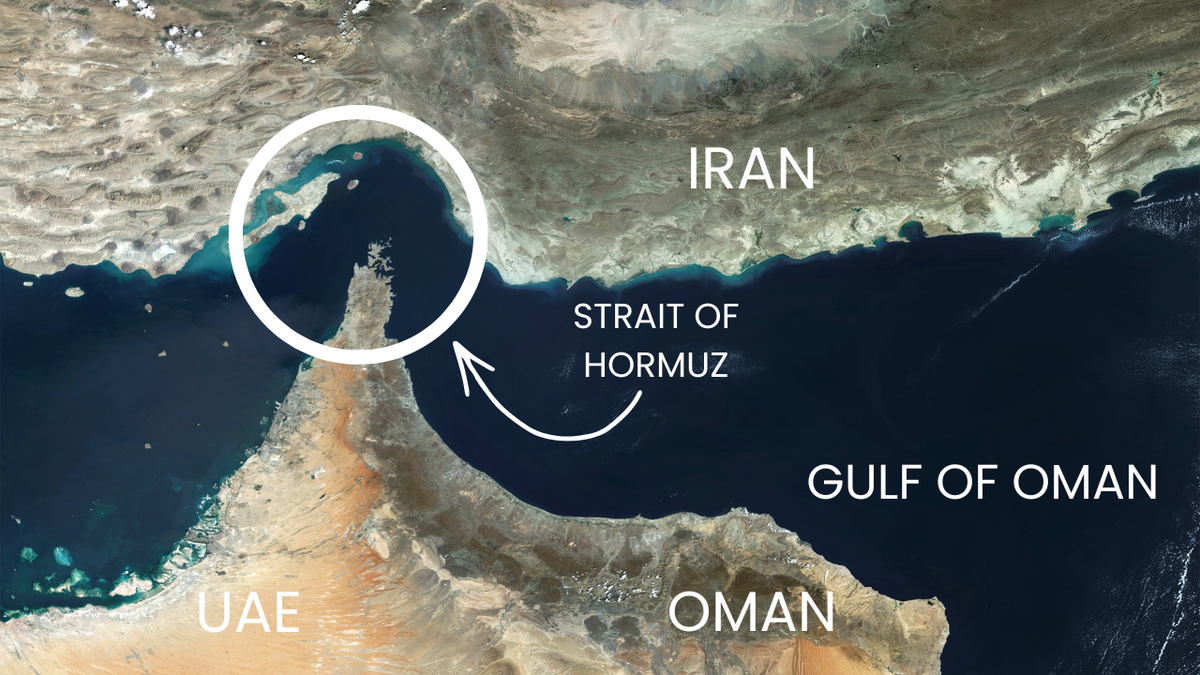
Marine News Room
Lloyd's seeks solution in Persian Gulf: "A thousand ships are at a standstill." 06 March 2026