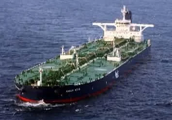
While the UAE bypass canal is out of the question, as is a ship tunnel, a canal with a few locks at the tip of Oman sounds like a very interesting option
By: Pablo Rodas-Martini
Holds a PhD and MSc from Queen Mary University of London. Former Chief Economist and Op-Ed writer
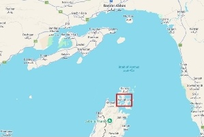
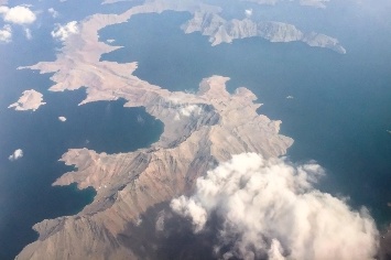
It is a secret, hidden in plain sight. It is so relevant, given the current drama at the Strait of Hormuz, yet no media outlet has mentioned it at all. I stumbled upon it while examining the map of Oman's Musandam Province on Google Maps. The province is located on the southern side of the Strait of Hormuz, facing Iran's Hormozgan Province to the north.
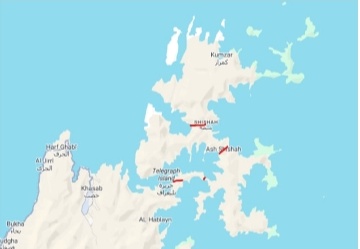
Zooming in on Google Maps, I noticed that a very short canal could potentially be constructed in this area, given the numerous inlets. This part of Oman is often referred to as the 'Norway of Arabia' because of its fjord-like coastline, even though these features are not technically fjords.
The four segments that I have marked on the map
The four segments that I have marked on the map could potentially be used for construction. I didn't use any sophisticated methods to identify them; I just looked at the width of the 'isthmus'. I then copied and pasted the map into ChatGPT and asked it to estimate the distance and average altitude. A canal could not be built if the elevation was 500 metres, but it would certainly be possible in a 50- or even 100-metre segment.
ChatGPT was of no help regarding heights,
ChatGPT provided distances ranging from 2.1 km to 5 km for the four segments. However, it was of no help regarding heights, only stating that some parts of the Musandam province could reach 900–1,200 metres, and that the peninsula's highest point is 2,087 metres.
UAE bypass canal mega-project
As nobody has mentioned the possibility of building this canal, but many have mentioned the truly absurd UAE bypass canal mega-project — a 180 km project across the Al-Hajar Mountains linking the Gulf coast near Dubai to Fujairah — I decided to look into the history of Musandam.
And there it was!
I found that the British explored the Maqlab–Al Maksar region in the 19th century, and that the Royal Geographical Society's Musandam Expedition conducted detailed research in 1971–1972 to investigate the feasibility of constructing a canal. However, it never came to fruition — who would have thought that a canal would have been needed before the Iran War?! What was once considered absurd became a fascinating and relevant issue after the war.
British records
When the latter expedition examined the feasibility of cutting through the Maqlab/Al Maksar isthmus, they found that the ridge between the Elphinstone and Malcolm inlets was the best option. British records had already placed the lowest point of that ridge at about 61 metres above sea level, and later published accounts described the isthmus as less than 300 metres wide at its narrowest point.
Distance is only one factor
I was amazed to read that it was only 300 metres wide! Compare these figures with those of the Panama Canal, which extends about 82 km from deep water to deep water, and the Suez Canal, which is about 193 km long.
Of course, distance is only one factor. There are many other factors to consider — tides and geology are two of the most critical.
Due to the tides,
Due to the tides, the expedition in the 1970s found that sea levels could differ by up to one metre, and the challenging hydraulic conditions led the survey team to conclude that locks would be essential for a real canal.
The French attempts failed for this reason
However, the main problem lies in the soil itself, particularly its geology. The Suez Canal is a sea-level canal that was constructed by excavating sand and clay from low-lying terrain in the 19th century. The Panama Canal presented a greater challenge — the French attempts failed for this reason — as it involved cutting through volcanic soil and rocks at a greater height, creating the artificial Lake Gatun in the process. This sits around 26 metres above sea level.
With modern technology, the work can be done.
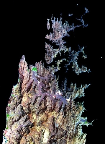
The geology of Musandam is completely different: it is a carbonate mountain massif dominated by thick layers of hard rock, mainly limestone and dolomite. However, I believe that, with modern technology, unlike that used for the Suez Canal in the 19th century or the Panama Canal in the early 20th century, the work can be done.
Of course, I am also well aware that, even though the shortest distance between the two inlets is supposed to be around 300 metres, the canal would have to cut a much longer distance, as the inlets would need to be properly deepened to create the necessary traffic lanes.
At this stage,
At this stage, tunnels naturally come to mind. This is how modern engineers overcome mountains. Europe crosses the Alps by tunnelling through them rather than cutting them open from ridge to valley. Iconic projects such as the Gotthard Base Tunnel demonstrate the achievements of determined engineering.
The planned Stad Ship Tunnel in Norway,
A more relevant example is the planned Stad Ship Tunnel in Norway, which is designed to allow ships to bypass one of the most exposed and treacherous sections of the Norwegian coast. However, examining the project reveals why a similar solution would be far less feasible in Musandam. At approximately 1.7 km long, 36 m wide and 50 m high, the Stad Ship Tunnel would have a ceiling 33 m above sea level. Although its construction would require the excavation of around 3 million cubic metres of rock, the tunnel is designed only for coastal vessels, with a maximum sailing width of around 21.5 metres. Compare that with the largest tankers (the ULCCs), bulkers (VLOCs) or container ships (ULCSs). It is almost like comparing a bush with a huge oak tree. In other words, one cannot compare a coastal route ship to serious vessel traffic.
Size is once again the main issue
Size is once again the main issue, not to mention the other problems. Ventilation, evacuation, fire suppression, salvage, collision risk and rescue inside a ship tunnel are challenging enough as it is. Add tankers to the equation, and the danger becomes obvious: a fire or explosion in a confined maritime tunnel would be catastrophic. Even the much smaller Stad project required fire, risk and ventilation studies.
Related: Pablo Rodas-Martini writes : The 'topography' of the Strait of Hormuz
The best option : The Strait of Hormuz in a peaceful Middle East.
So, while the UAE bypass canal is out of the question, as is a ship tunnel, a canal with a few locks at the tip of Oman sounds like a very interesting option. The best option of all would, of course, be the Strait of Hormuz in a peaceful Middle East. However, now that Iran has realised the incredible power that comes with controlling the strait, I fear that blocking the strait it will become a common tactic in future crises.
Source :LinkedIn
#Pablo Rodas-Martini # UAE # tip of Oman #ChatGPT #Strait of Hormuz #Stad Ship Tunnel #Suez Canal#Panama Canal#geology of Musandam#Gulf coast#A feasible canal#British records
You Might Also Like
Recommendation News

Shipping Lines
APM Terminals and Hateco Group continue a successful partnership with new terminal in Da Nang 27 April 2026
Marine Tech
Nanni tests the first high-speed dual-fuel engine that runs on methanol. 24 May 2026
Incidents
The Russian Metagaz LNG carrier, Arctic, approaches Malta- Details 16 March 2026
Ports
President Mahama commissions phases 1 & 2 of $1.5bn Tema Port expansion project 16 November 2025